
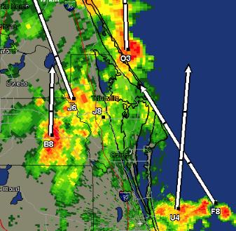
AccuWeather.com) - As Tropical Storm Alberto continues to move slowly through the eastern
Gulf of Mexico and toward the northwestern coast of Florida, heavy rain and thunderstorms will continue to deluge the Florida Peninsula. The storm will move over northern Florida Monday night then race past the Eastern Seaboard during the middle of the week. Tropical Storm Alberto remains a poorly disorganized storm with the center of the storm west of the main area of thunderstorms. Heavy rain and winds to tropical-storm force have already lashed Key West, and bands of showers and thunderstorms have already spread into the central Florida Peninsula. Key West reported a 48-mph wind gust, and Sand Key reported a 67-mph wind gust. The gusts occurred in thunderstorm squalls that crossed the Keys this morning. For a complete picture on the rainfall, check out the Key West Radar.
The strong winds in the upper levels of the atmosphere have caused the main band of rain and thunderstorms to shear northeastward away from the center of Alberto's circulation, these strong winds have also prevented Alberto from undergoing any further intense intensification. The shear will continue to shed the main piece of energy (the rain and thunderstorms) away from Alberta Monday, while Alberto's main yet weakened and disorganized circulation will just sit and spin over the open Gulf of Mexico. Despite Alberto's main circulation being separated from the rain and thunderstorms, the separated piece of energy will still deluge the Florida Peninsula through Tuesday with heavy rainfall and thunderstorms. The piece of energy will move over northern Florida Monday night then pass back into the Atlantic Ocean Tuesday morning. Most areas across the central and southern Florida Peninsula will receive 4-8 inches of rainfall through Tuesday morning. This is good and bad news for Florida. The good news, they need the rain; the bad news, the rain comes all at once and may result in flooding. In addition to the heavy rain, winds will be gusting at 30-40 mph with occasional gusts to 50 mph, mainly along the western coast of Florida. There will also be an increasing tornado threat from south to north the next 24 hours as the rain bands from the storm creep northward.
Just what we need here ...... Rick

No comments:
Post a Comment